Showing posts with label trekking. Show all posts

Wednesday, June 18, 2014

Trekking through Bulgaria's Central Balkan Mountains

I just finished rereading Bill Bryson's A Walk in the Woods- a wonderful and very funny story of his section hikes through the Appalachian Trail that runs the distance from Georgia to Maine in the US.  I had picked the book up in Bled, Slovenia back in April - perhaps one of the last places that we've seen a fruitful book trade.  Nate and I watched the girl who was finishing the last chapter- and pounced on it when she added it to the book exchange shelf it.  I've been carrying it around since then along with a few others in my traveling library, convinced that the enjoyment of reading them would outweigh their toll on my back.  I feared that the English books would eventually run out so, I'd rather have a few on hand (which has now happened- the Balkan's has an abysmal book trade, English language or otherwise).  

As we reached our departure date for trekking in the Central Balkans, I knew that I had to get rid of any extra weight so I read voraciously- leaving books hidden in drawers, in hopes that they would find a home with someone, rather than be tossed in the rubbish bin.  Thus, A Walk in the Woods remained my last and only book- fitting for our own upcoming walk in the woods.  

We had spent a few rainy days in Veliko Turnovo watching similarly rainy forecasts for Gabrovo, where we would start our trek.  We delayed an extra day in Veliko Turnovo but the weather didn't improve any, so we decided to just get on with it and hope for the best.  Our next obstacle was that Gabrovo is not a tourist town- so there are limited hotels and they are all above our price range.  We didn't book anywhere and hoped that we could find a place once there; maybe an older couple would be at the bus station advertising their extra room, as we'd seen elsewhere???  No, no luck, there wasn't a soul at the station so we started walking towards town under increasingly threatening skies hoping that there'd be a visitors center with some kind heart who'd help us find an affordable room for the night.  We did find a map (mostly covered with graffiti) and a sign pointing us to the right building but we couldn't find the office itself.  We discovered that the office was in transition to another location across town but they called a woman to come over that might be able to help us out.  After much technical difficulty on a new computer system that no one knew how to use, our new lifeline eventually relented and used her phone to call around.  We gave her our budget range and were told that there were a few beds open at the local college dorm since students were gone for the summer. It was exactly as promised- hard to find, quite a ways out of town and cheap.  We ended up finding it- a large, dreary communist-type block apartment building within a sea of others- but we had a place to sleep so we settled into our college dorm room for two nights.  

While we didn't meet any of our neighbors, we quickly learned that the guy upstairs preferred his music to be played late at night and at a volumne loud enough to shake our window within it's pane.  I adjusted accordingly and took to having afternoon naps rather than my usual nighttime sleeping routine.  Nate instead took to yelling profanities at the guy in Bulgarian (which there's no way he would have heard over the music).  The weather remained dismal, but we couldn't stay in the dorm another night.  Our college days are long since over and we needed to get on our way, rain or not. 

The forecast for the following day would be cloudy but no rain until mid-afternoon.  We picked up a map at the park office, asked a few questions and planned our route so that we would reach our first stop before the rain.  


The actual start of the trail is in Etar/Etura but we decided to walk from Gabrovo and start up the first few kilometers of the trail and reach the first mountain hut near the monastery at a location marked GPS 7 on the bottom of the above map.  It was a nice walk and mostly flat until we reached the B1 trail in Etar.  At that point, we had to scramble up very steep and thoroughly rotten series of stairs and a several unmarked trail intersections but we did eventually reach the monastery.  We were thankful to know that soon we'd be in the hut, likely just minutes before the black skies above us opened up.  We passed the monastery and a sign advertising beer and BBQ.  We agreed that after a shower, we'd head back for both.  Life was looking good.

The mountain hut should be just a little further.  There were no signs for it and we were growing a bit concerned that as we continued on the trail that we had perhaps missed it and were walking further away.  We agreed to stop when we hit yet another unmarked intersection.  I stayed with our bags and Nate went back to see if he could find anything.  While waiting, I found a nice little camp spot under a tree that would buffer us from the rain.  We had hiked about 15 km already and the next mountain huts were in Shipka Pass, another 4-5 km on the opposite side of the Balkan mountain range.  

Nate returned to say that he had indeed found the hut... but that it was closed up.  Camping in the rain seemed worse than hiking in it- so, with that, we made a guess to turn right at the trail fork and carry on.  Within minutes, we passed by the back of the hut.  Not only was it closed but likely condemned.  I spent the next few minutes grumbling  and wishing that that the helpful girl at the park office had thought to mentioned it when we had asked if all of the huts were open.  We would soon learn that about half of the huts and hotels that are marked on the map had long since closed down.  As I summoned seemingly empty stores of energy for the additional miles, the rain began to fall.  It would have been a really beautiful hike up and over the mountain range, but the rain was heavy, visibility was minimal due to the thick fog and the trail was slick with mud after weeks of rain- sometimes even with unexpected sinkholes to keep things lively. 
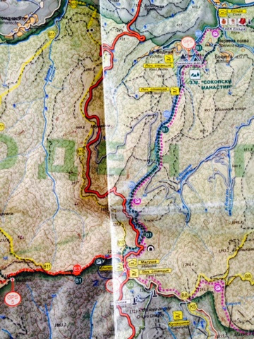

We eventually hit the road near Shipka (GPS 6, bottom where the fold is), our last hope for a dry bed.  We followed the road at this point in hopes of catching the first available accommodation.  After passing several dilapidated homes, gas stations and shops- I determined that sleeping in one of those would at least be warmer and drier than the woods.  Eventually, we came across a small sign for a hut. Two wet but friendly looking dogs greeted us at the top of yet another set of rotten stairs.  We made our way up and were thrilled to see lights on and a fire going. We attempted the door, ready to throw ourselves and our wet socks next to the fire but the door was locked.  After repeatedly knocking, pleading, and knocking some more- we resigned ourselves to waiting in hopes that the owners would eventually come back and throw another log on the fire before it died out.  We were both soaked and now that we'd stopped moving and night was setting in, I was becoming increasingly chilled.  My fingers were too numb to unzip my rain jacket to add additional layers so instead I put my head down on the picnic table and balled myself up around my hands to warm them.  With that, it seemed to Nate that I had lost all hope (he wasn't too far off the mark).  

We'd already been waiting for over an hour, we needed a back-up plan.  Nate took off to see if maybe there was another hut down the road while I stared at the fire wishing that there wasn't a locked door that separated us.  After a while, Nate came back carrying a fresh water bottle saying that he had found a shop just down the road.  He was only able to see it through the thick fog because the shop had a neon open light!  I'd always hated those things until that moment.  It was hard to believe that there was anyone for miles, much less just down the road.  It seemed like Nate, I and the two dogs were the only ones in the Central Balkan range.  The shop owner had told Nate that the hut was definitely open and that the owners had probably just gone into town.  That gave us a renewed hope and after another hour or so, they indeed drove in and showed us to our room.  Within minutes we had showered, had our things out to dry and were on our way down as new people for a hot meal followed by a warm, comfortable nights sleep.

When we went down for breakfast the next morning, it was like walking into a different dining room.  The entire room was now festive with party napkins at each table setting.  We found seats and sadly watched two full plates of cherries removed from before us to be served instead to their proper recipient.  I must have been busy staring at the cherries because it wasn't until then that looked out of the window and instead of seeing the previous day's thick fog, I instead saw lines of tour buses and a massive monument perched ontop of a hill before us! 

We spent an extra day in Shipka Pass to rest and hike up to the monument between rain showers.  


We had a lovely day of sunshine the following day as we walked along the road from Shipka (on the left) to Buzludzha (GPS 8, on the right), the site of the Communist monument build in the 1981 and then abandoned and left to elements only a few years later.  


We passed by the monument on our way to find our next hut.  The first couple that we saw were abandoned and we were forced to walk further than we had hoped in search for a bed.  After finally reaching one, we were told that it was full.  Full?  We had been the only two people in a huge hut the night before- how was this one full?  Again it was a race before the rain started so I again watched the bags and Nate and his knowledge of Bulgarian went off in search of a room.  Turns out that there was one close by- we had walked by it but I had thought that it was just a private home.  Again, we were the only people there.  We dropped our bags, had a late lunch and set off with our rain gear to see the monument.  

It's a "healthy" climb up the steep path to reach the monument.  There's also a road for those with cars or motos.  The monument looks far better from below- as you reach it, you can see that the strong winds have ripped most of the roofing and ceiling materials off.  


With all of the rain, I imagined the inside to be the world's largest bird bath but we could hear people inside. We walked around the perimeter and only saw a small hole, which we learned later that yes, that was the entry point for the interior.  


That night, yet another massive rain and lightening storm rolled in right above us on the mountain and stayed the following day.  We took it as a sign to stay an extra day, plus the owner made a fantastic lentil soup.  The company was good too. 


It turned out to be a good thing that we stayed (other than the fact that we would have been miserable hiking with lightening dancing around us).  That afternoon 4 guys from Sweden who are riding their motorcycles around Eastern Europe stopped in while waiting for a mechanic.  They spoke English but no Bulgarian, the owner spoken Bulgarian but no English and the mechanic who showed up at 9pm (rather than at 5 as he had promised) spoke only Bulgarian.  Over dinner, Nathan became a key player in translating the complexities of BMW repair while I happily slurped up my lentil soup.  The guys were great and we really enjoyed hearing their stories.  Around 10, they learned that their bike would have to be towed to Sofia the following day, so they settled into the remaining rooms and pulled out a home-made bottle of liquor, made by the owner of a guesthouse that they had stayed at when in Romania.  The next morning, we shook off the mental fog left by the previous night's home brew to see the guys off and get on our way.  We continue to follow their trip at RushHourMC on Facebook.  The current trip is winding down but they have others planned for the future, including one through the US. They also took a video from inside of the monument that you should definitely check out as well as their FB page.  http://youtu.be/czWfMjFN09c 


With that, we were off as well. We had planned on hiking another few days but the rain showed no signs of clearing so we decided to bail and head for Stara Zagora.


We followed a seemingly never-ending switchback (the white squiggly line in the center of the map to the left of the fold) down the mountain for 19 km until we hit the tiny town of Kran.  Although we were positive that we were standing at the bus stop, not a single bus stopped for us.  Eventually a taxi came to our rescue and took us to the bus station in the next town over.  

Now a week since we got off the trail, it's STILL raining.  When I think of all the folks hiking the Appalachian Trail or similar long-distance trails with no mountain huts to find warmth in, no one to cook them delicious lentil soup after a cold/rainy trek and no option but to hike in the rain, it makes me feel blessed to be hiking here in Bulgaria.  We loved the Annapurna Circuit Trek in Nepal for the same reason.  It makes a huge difference when you don't have to carry the additional food weight and alway trust that you could find a fire and a meal to warm you up (although obviously in the Central Balkans- it is a bit of a search to find a functioning hut).  

Our next trek will be in a few days in the Rila Mountains- and the forecast is looking better!

Happy Trails. 


Wednesday, October 30, 2013

Trekking Nepals Annapurna Circuit

Since college, I've dreamt of trekking in the Himalayas.  I had seen images of prayer flags with the gorgeous snowy mountain peaks as the backdrop.  Almost 15 years later, those images spurred an amazing adventure for us while here in Nepal!  We decided to do the Annapurna Circuit trek- which offers some of the best views of the Annapurna mountain range.  

Within just a few days of arriving in Kathmandu- we made our way through the city's hectic streets to the permit office where we paid $40 each for our trekking permits (TIMS and ACAP).  If we had known the absolute ease and simplicity of life in lakeside Pokhara- we surely would have waited to get them there.  When applying for the permits, we had to tell the permit coordinator our start date for the trek.  We had no idea and threw out a date two weeks in the future- October 7th.  So then the date was set and permits were given- we were doing it! 


Annapurna Circuit Trek, Nepal
 

POKHARA 
Pokhara lays 6 hours northwest of Kathmandu and is often the start/end point for those trekking in the Annapurnas.  

So, after a week in Kathmandu, we took a bus to Pokhara to start prepping for our trek.  The streets are lined with knock-off brand-name clothing, backpacks, trekking poles and anything else you could want on your trek.  The prices are negotiable and the quality seems decent- but I wouldn't expect the gear to last much longer than your trek.  We picked up a map, pair of trekking poles, a few quick dry shirts and restocked our first aid kit.  While our bags were ready- we weren't quite sure our bodies were ready- so we started doing day hikes in Pokhara to strengthen are legs for all the climbing that we'd be doing. 


One of the many outdoor stores in Pokhara.

POKHARA DAY HIKES
There are two fantastic day hikes in walking distance of lakeside Pokhara that we took advantage of before the our trek.

WORLD PEACE PAGODA
The world Peace Pagoda sits high on the hill on the opposite side Lake Phewa.  You can either take a boat across the lake to the trailhead or you can walk around the lake.  We did both- but I'd recommend taking the boat across and then returning by land (so that you understand where the unmarked road comes out incase you want to go a second time but by land).  Or you could take a taxi almost to the top which would probably be a 20 minute ride up a bumpy dirt road.  The pagoda is well worth the visit!  From there, you can see Lake Phewa, the Pokhara Valley and if it's a clear day- the Annapurnas.


World Peace Pagoda across Lake Phewa from Pokhara.
 
SARANGKOT 
The nearby Sarangkot mountain summit has unobstructed views of the Pokhara Valley and the Annapurna Range.  Many make an early morning trip (or stay over the night before) to catch the sunrise views as the sun hits the mountains.  Also every day, hundreds of tourists take a 30-minute paraglide from the top down to the lakeside landing point for about $85.  We, being neither early risers nor fans of our feet being off perfectly safe ground decided to hike up to the 1,592 m/5,223 ft summit.  It's a long, steep climb but we really enjoyed the views and meeting the locals as we passed by their homes on the old stone trail.  Plus, lunch at the top was fun as we watched the paragliders take off just below us.  I've read that the taxi takes 45 minutes or so and then it's a 30 minute hike to the top.  However you get there- it's a beautiful way to spend a few hours.


View from the summit of Sarangkot. Photo credit: www.trekking-in-Nepal.net

Paragliding from Sarangkot. Photo credit: www.trekking-in-Nepal.net
 
THE ANNAPURNA CIRCUIT TREK
At 6:30am, our bus departed from Pokhara and took us to Beshishar- which is the start of the trek if going counter-clockwise (highly recommended due to the ability to acclimate slowly before crossing the 5,416 m/17,769 ft Thorong La Pass). 

The Annapurna Circuit trek has been considered one of the best treks in the world.  It encircles the Annapuna Mountains and takes you through several different climate zones, small villages, by hundreds of waterfalls and unforgettable landscape.  One of the many highlights of this trek is that you do not need to be weighted down by pounds of food or camping gear!  This is a "tea house" trek, meaning that there are many lodges and restaurants along the trail.  Other than the day we crossed the pass, there were places to eat at least every 2 hours and often within just a few minutes of one another.  The rooms are cheap- $1-3 a room if you eat at the lodge.  While the room rates stayed about the same, the cost of food steadily increased as we climbed higher in elevation and further from the road system- starting around $2.50 and getting as high as $5 for a meal.  It's best to estimate $20/day so that you have money for lodging, food, snacks and pots of tea to warm you up after a long day. 

The entire circuit is between 17-21 days but because of the number of towns and the ever-developing road system (which now threatens it's ranking as one of the world's best treks) you can make the trip in as short as week if you fly out of Jomsom ($120) or alternatively, you can make it as long as you'd like- as long as you have enough cash with you.  We hiked for 11 days and added a few other days for either resting or acclimatizing at the higher elevations.  

Many trekkers had guides, porters or both.  I think porters cost about $15 a day and carry an astounding amount of weight.  I hope that the payment for the porter goes up based on the weight they're carrying.  The trail is steep, rocky and often muddy- so it's hard enough to traverse safely with the weight of one pack, let alone the weight of several.  If you carry your own bags but want a porter to take your pack(s) over the pass (which is by far the most difficult and longest day)- a porter will cost around $100.  We have never trekked anywhere with porters so quite honestly, it didn't even occur to us to have someone else carry our bags, so we were rather surprised to see how many trekkers used this service.  It's good money for the porters; I've read that the amount of portering once around the circuit is enough to feed their family for several months.  We are by no means setting any records for our physical fitness and we managed just fine with our own packs but I can obviously see the up-side to carrying less weight (like my knees and back probably wouldn't still be sore!)...  So, while I think a porter could be advantageous- I really don't think a guide is needed unless you're going when there's inclimate weather.  The trail is well marked and there are lots of locals or other trekkers who will reroute a misguided trekker.


Red and white trail marker.  If you can read this, you don't need a guide.
 
Looking for more info on the Annapurna Circuit? My blog doesn't have a lot of the nuts and bolts info- so if you're looking for that, try: http://www.livingif.com/himalayan-hiking-logistics/ and http://wanderingsasquatch.com/how-to-hike-the-annapurna-circuit/

OUR TREK
We covered 164km/102 miles in 11 days of hiking.  I think most days were between 6-7 hours with some longer and some shorter days.  As we got further into the hike, the climbs became steeper and slower, so most of our miles were covered early on in the trek and on our final three days which were downhill or relatively flat.  

After 4 days of hiking 56 km/35 miles and climbing 1,890 m/6,200 ft in elevation, we took a much needed rest day in Chame (mostly because we found wifi there).  Two days of trekking later, we arrived in Manang- where we would acclimate for two days at 3,540 m/11,614 ft.  Since acclimating here is recommended for all trekkers before ascending any higher, Manang is well adapted for the large number of trekkers who stay here.  There are two movie houses (that we went to THREE times) that have a woodstove or gas heater inside.  About halfway through the movie, they serve hot black tea and popcorn.  For $2.50, it was the perfect place to relax and stay warm.  Manang also has several amazingly tasty bakeries to help regain some of the curves that were lost on the hike.  We even found Mexican food there!  


A hillside Gompa in Manang with the Monistary perched high above in the mountains where we received blessings from the Monk. 

There are several days worth of day hikes or multi-day side treks one can do around the area for acclimatizing. The rainstorm kept us indoors on our first day but on the second, we hiked up to the monistary high in the mountain behind Manang.  A monk lives there who gives blessings to trekkers who will cross Thorong La Pass.  She is the daughter of a 97 year old Lama, who gave blessings before her.  The Lama is now ill and has been taken to Kathmandu and she has taken his place.  The trail takes you past the Gompa (pictured above) and then high up into the mountain.  Once reaching the site and catching my breath, I knocked on a small wooden door and said hello (or rather "Namaste") in a volumne that would neither disturb someone resting but would hopefully be heard by someone.  There was no answer, so Nate and I tucked ourselves within the cave that the Monistary was built into in order to get out of the rain.  We figured we would take advantage of the high altitude to better acclimate ourselves.  And then I heard a tarp rustle and ran around to see if someone was there.  She was!  She was up on the roof grabbing firewood.  I greeted her and she waived us in with a huge smile.  The stone and wood timber structure had two very simple rooms.  One seemed to be her living quarters and the other room was the one that she brought us into.  The room low and covered with aging Tibetan Buddhist scrolls and photos of the Dalai Lama.  She sat behind a low table and asked us to sit on the pillows opposite of her.  She asked that I bring my head towards her and she placed a braided string around my neck and said a prayer as she touched my head- of which I only unsderstood 'Thorong La" and then she tied off the string.  After she did the same for Nate, she gave us two steaming cups of tea to warm us up before we made the return down the mountain in the rain (arriving just in time for another movie!).  I didn't take any pictures inside but did take this one from the Monistary of Manang and the surrounding valley.

View of Manang from above.
 
The following day, the rain finally stopped and we were ready to get moving again.  We chose poorly, because just a couple hours into the trail, the weather turned ugly again.  By the time we stopped for lunch, we were drenched and cold.  While our food was cooking, I ran around town looking for a room.  The weather conditions had people staying put- very few trekkers had left from the night before and as others were arriving, like us, they decided to stay.  Everywhere was sold out.  As I returned for lunch, I saw that our lunch spot had a very basic room- that was available!  


Drying out by the fire while lunch is cooking in Yak Kharka.
 
The next day, we took our chances on the weather and left Yak Kharka as snow flakes were starting to fall.  Thankfully, the snow stopped as quickly as it started and the weather held.  Unfortunately, as we arrived to the Thorong Phedi base camp- we ran into the same problem.  The two lodges were sold out.  The lodge owner offered us the option to sleep in the dining hall which we readily accepted- although we knew that it would mean less sleep before our most challenging day of crossing the pass. 


Signs at the entrance to Thorong Phedi base camp.
 
After a warm lunch- we needed to further acclimate so we climbed or rather scrambled up the 400 m/1,312 ft goat trail to High Camp.  It took about an hour without a pack and had me so winded and my heart beating so fast, that I became seriously concerned about altitude sickness.  That night, as we waited for people to clear out of the dining hall- we discussed our options.  We knew that folks would be waking up early in an attempt to reach the pass around sunrise- so we decided that we would wake up early and make it was far as High Camp and have some tea there.  If the altitude was an issue, we could either stay at High Camp or return to Base Camp.  People started waking at 2:45am- yea, I really couldn't believe it.  Snow had started to fall the night before so I was surprised that folks would be going up such a dangerous trail with only their headlamp for light.  Nonetheless, we fell blissfully back to sleep once the room quieted down and then woke up around 6am when the second wave of folks were up and moving.  
 
My climb to High Camp the following day was much easier the second time.  We went "slowly, slowly" as the locals say- but I didn't need as many breaks as I did the day before and my breathing and heart rate seemed much more controlled.  We still stopped for tea at the top but had already decided to keep going.  At that altitude, every movement is as if you're wading through a rushing river.  My legs felt heavy and sluggish. It was another three hours of a slow shuffle step until we reached the highest point of the pass.  We stayed just long enough to congratulate ourselves, take a few snapshots and then with desperation, get ourselves to a safer elevation.  
 

The Thorong La Pass at 17,760 feet.


We made it to the top!


Views of the surrounding mountains from the pass.
 
The trail then became a steep, knee-grinding descent for another four hours- dropping 1,616m/5,302 ft until we reached Muktinath.  I don't think we thought much about food until dropping a couple thousand feet down.  There's no where to eat- as the landscape is a complete desert of loose rock from centuries of avalanches.  But, we had a couple of candy bars- still frozen from the mornings cold weather to tie us over.  

The valley surrounding Muktinath finally appeared from below the threatening clouds and we made our final decent into town- summoning the very last of our energy to drag ourselves into town and find a bed to collapse into.  


Our view as we started to descend towards Muktinath.
 
We caught a jeep to Jomsom the next day, avoiding the dangerous and horribly dusty road.  The rains caught up with us again in Jomsom.  We had found an amazing place to stay aptly called "Paradise" with the first hot shower we had had in over two weeks and strong wifi.  We stayed for three nights while we waited for the local ATM to get fixed.  We thought about flying out but the airlines only take cash- and we didn't have enough.  We did have enough cash for the bus but thankfully we read about the 15-hour, nail-biting experience other trekkers had and decided against it.  So, we loaded up our bags again and kept walking.  We both loved the walk- the weather cleared and the views were lovely.  The road had less traffic than we had expected.  The only downside was that the winds blow very strong in the area and it's hard to keep your eyes and lungs protected from the dirt.  It's inevitable- all trekkers end up looking like trail bandits.


Attempting to avoid the dust storms.
We trekked for another two days, covering long distances since we were no longer climbing.  Both the road and trail suffer from constant landslides, so we chose the road in hopes that it was safer.  Here's a fresh landslide that we crossed with a bus in the distance encouraging passengers to disembark before the bus attempted to cross.

A recent landslide on the road ahead.
 
Nate bravely crossing.
The landscape became green and lush again as we descended to lower altitudes- until we reached Tatopani, which reminded me of being in Hawaii.  Just as we approached Tatopani, Nate turned back to tell me something and saw this stunning rainbow shining brightly behind us.  


Rainbow in the final mile of our incredible trek around Annapurna!
 
From Tatopani, we thought it would be safe to take the bus back to Pokhara.  I will just say that it was the scariest ride of my life.  We should have walked the final two days...

OTHER PHOTOS FROM OUR TREK:
 

Our first bridge crossing in Besisahar.


We were blessed on our second day of the hike.


Checking the map at a large stand of prayer wheels.


Porter ahead of us on the trail.


Sharing the trail.

We started seeing Tibetan mani stones once reaching Chame.
 

The Upper Pisang trail passes though many old towns like this one, with rock and lumber construction.
 

First bridge we crossed when taking the Upper Pisang side trek.
 

View of Upper Pisang. 
 

Sunset view from Ghyaru, on the Upper Pisang trail.

Riverside trail coming into Kalopani.
 

We are heading back to Kathmandu for a few days and then north to the Langtang region for another trek which will take us into a remote Tibetian region of Northern Nepal.